Philippines

The Hidden Wonders of Surigao Del Sur, Philippines

I originally packed for a 4-day Davao City trip. This is my first time to ever visit a Mindanao province. I expected it to be very similar with Cebu and Manila – malls, markets, traffic, and lots of people. Well, I wasn’t wrong, but the real perks come into 3 things 1) eating lots of FRUITS :), 2) meeting the famous Mayor Rod Duterte, and 3) being accessible to the rest of Mindanao provinces by land. Not bad! 🙂

How lucky can we get to catch Mayor Rod Duterte during our 1st dinner in the city!

How lucky can we get to catch Mayor Rod Duterte during our 1st dinner in the city!

Davao City is approximately 440 miles south of Manila, Philippines. It is accessible by plane or by boat. It is the top city of Mindanao, similar to how Manila is for Luzon, and Cebu for Visayas. Overall, I thought it was ok. We did not go around a lot since it turned out that we will be driving out to Surigao Del Sur on our 2nd day. Surigao sits around 153 miles (246 KM) north of Davao – approximately 4-5 hours by land.

I was anxious leaving Davao for another province. I never knew what to expect from other Mindanao provinces due to the fact that this part of the country is quite infamous in the local news. Passing by towns in  Compostela Valley, Agusan Del Sur, and finally Surigao Del Sur makes me wonder what in the world would I find interesting here.

After 3 hours of zigzag highways and another 2 hours of rough roads (the roads were under contruction!), we finally touched down in Bislig City, home of the majestic Tinuy-an waterfalls. It boasts its name as the widest waterfalls in the country – Niagara of the Philippines. Well, it did not disappoint. I was impressed by how vast (and high) the waterfalls is. 🙂

The grand Tinuy-an. This is the 1st level and main waterfall that measures  95 m wide and 180 ft high.

The grand Tinuy-an. This is the 1st level and main waterfall that measures 95 m wide and 180 ft high.

It was awesome seeing the grandeur of this hidden gem, but it was a lot more exciting to actually go into the foot of the falling waters by bamboo raft. Water falling strong at the top of your head and back does not come close to any hard massage you can get in Manila. LOL.

Bamboo raft used to traverse the foot of the falls.

Bamboo raft used to traverse the foot of the falls.

We rented one of the large cottages at the main camp area of the falls. It was cheap for a daytime rate of Php500 big enough for 12-15 persons (plus minimal entrance fee per head). After a hearty lunch, we set out to explore the 2nd and 3rd levels of the falls. The upper levels are more conducive for photos since you can sit on the rocks by the falls.

2nd level is shallower than the main falls. You can sit by the rocks for some great photos.

2nd level is shallower than the main falls. You can sit by the rocks for some great photos.

I like the 3rd level with this picturesque rock formations.

I like the 3rd level with this picturesque rock formations.

After a few hours and a lot of great photos, we packed up and checked-in at a nearby resort, Sand Bar. It was nothing fancy, so I won’t touch on that in this post.

The next morning, we were out set to discover the Enchanted River in Hinatuan City. By far, this is the best brackish water river I have seen. I am not a good swimmer, but I really could not help but dive into the clear water! Thank God they had life vests for rent! 🙂

A sneak peek into the blue waters of the enchanted river.

A sneak peek into the blue waters of the enchanted river.

Enchanted river diving area. Notice that the water is flowing from the underwater cave in the background.

Enchanted river diving area. Notice that the water is flowing from the underwater cave in the background. Photo credits to Marcial Bolen.

Taken from the other end of the river where the water current goes.

Taken from the other end of the river where the water current flows.

Don’t be deceived by the people swimming happily by the lagoon. When I tried to guess how deep it was, I was surprised to see an abyss-like crater with no clear bottom. Records say the front part is around 25-50 ft deep, but the depth of the inner part inside the cave is still unknown.

Under water shot show an abyss-like crater at the bottom - approximately 25-50 ft deep. Photo credits to Marcial Bolen.

Under water shot shows an abyss-like crater at the bottom – approximately 25-50 ft deep. Photo credits to Marcial Bolen.

By noon, all swimmers were advised to get off the water for fish feeding time. Suddenly, a lot of types of fishes, big and small, came by the surface for food. 🙂 We stayed for a few more hours swimming. I did not want to leave!

I just wished they had better and a lot more bathrooms available. With the long queues, we had to make do taking a “bath” at the deep well outside the changing rooms. By 3PM, we left to drive back to Davao.

Surigao Del Sur will not usually make the bucket list of people as a place they want to visit in the Philippines. I thought that way too before I got here. But, this place just proved me wrong. These 2 hidden wonders make my list as “must-see” places in the country. I would recommend to book your flights to the nearer Butuan City airport. It would take half the time to drive here compared to coming from Davao City. I would definitely not hesitate to come back! 🙂

Anawangin-Nagsasa-Capones and the Great Outdoors

My family loves the outdoors. I grew up used to going to remote places, building camping tents, and sitting by a bonfire as a typical family getaway. I was ecstatic when I learned that my friends and I will be going out for a camping trip in Zambales for a weekend. Yey for me, yay for them- it was their first time.

The municipality of San Antonio in the province of Zambales  lies around 160 kilometers north of Manila, Philippines. It is in the same province where the (in)famous Mt. Pinatubo rests. After the 1991 eruption, locals say that the ash deposits from Mt. Pinatubo accumulated in some remote parts of Zambales forming pristine (grayish) white beaches. What makes these beaches special is the sudden growth of pine trees by the shore – not a very common sight in most tropical beaches in the country. Most famous ones are found in Barangay Pundaquit in San Antonio – Anawangin Cove and Nagsasa Cove. A nearby island meanwhile houses an old lighthouse in a picturesque landscape – Capones Island. These are only accessible by boat from Barangay Pundaquit.

Sunset in Nagsasa Cove. Photo Credits: Simon Floreza

Sunset in Nagsasa Cove. Photo Credits: Simon Floreza

How to Get There

We tried researching for directions from the net, but we ended up using Waze because we were too lazy to refer to our printout everytime we need to take a turn. Believe me, Waze is a life-saver. 🙂 Anyway, for your peace of mind, here’s a rough guide on how to get to the Brgy. Pundaquit Barangay Hall. This is usually where you’ll be meeting your contact for boat rental.

1. Drive towards North Luzon Expressway (NLEX). Depending on where you are coming from in Manila, you can take either the Mindanao entry (nearer from C5), or the Balintawak entry (nearer from EDSA).

2. Drive to the end of NLEX connecting to the Subic-Clark-Tarlac Expressway (SCTEX). Exit to the path going to Subic (beware of the signs!).

3. Enter Subic Bay Metropolitan Authority (SBMA) and just go with the flow (I assume majority of the cars are headed to the SBMA exit :P) The exit is towards the end of Dewey Street. Please be cautious of the road signs if you don’t want to get a traffic violation. If you see a STOP sign, you should stop (not yield). 🙂

4. Once you see the Olongapo Cemetery, turn left and just stay on the road heading towards Iba, Zambales. This is a long drive. You’ll pass by a lot of towns and zigzag roads. Be patient.

5. When you reach the municipality of San Marcelino, drive to the Public Market where you’ll see a Y junction. To the right is heading to Iba, to the left is heading to San Antonio. Of course, you should turn left.

6. Drive until the San Antonio Municipal Hall. This is where it gets tricky and Waze will eventually save you. Turn left to the road heading to Brgy. Pundaquit. They said you’ll see signs, but we didn’t LOL. 😛 If you don’t have Waze, just ask a tricycle driver.

7. Head towards the Pundaquit Barangay Hall. You will see a lot of boat rentals there, but for convenience, I suggest you contact one ahead of time. You should be able to park your vehicle in designated areas depending on your boat rental contact. In our case, we parked in the backyard of Ate Luisa’s house.

What to Bring / Tips for the outdoors

Anawangin or Nagsasa is where you’ll most probably set camp. These are very remote areas – no electricity and no mobile service. Non-potable water for bathing and public toilets are available for free. I think there are around 6-10 cubicles each for Anawangin and Nagsasa (half toilets, half showers). Other than that, all other goods for sale (i.e. potable water, candles, sodas, etc.) are 150%- 200% of the usual price (I swear!). Here are some tips to help you survive your stay and save some money.

Anawangin Camp Site. The boys busy figuring out how to set up a tent.

Anawangin Camp Site. The boys busy figuring out how to set up a tent.

Anawangin Camp Site. Finally! 1 tent up, 2 more to go!

Anawangin Camp Site. Finally! 1 tent up, 2 more to go!

1. THINK AHEAD of what you’ll need. If you have your own vehicle, bring an icebox/cooler, a portable stove, drinking water, camping light/flashlight, sleeping tents and beddings, and eating/cooking utensils (disposable or not – plates, spoon, fork, knives, scissors, cups, at least 1-2 cooking pot/pan). Your guide and porters will be helping you carry all these from your vehicle to the boat and to your camp site.

These are all also available for rent from your contact. However, for sanitary issues, I prefer to bring my own. You can also find someone to cook food for you for a price, but in our case, we ended up cooking for ourselves. This should also help you save money. Just to share, we ran out of butane in the morning and we needed to boil water. We asked the store if we can use their stove to boil OUR water in OUR pot – they charged us Php50/$1 (just for 5 minutes use!).

You should also bring powerbanks and waterproof cases. We weren’t able to take as many pictures when we reached Capones since we only brought 1 battery-drained camera from the boat (I didn’t want to risk my DSLR getting wet since we had to swim to the shore!).

2. Bring FOOD. Before we headed to San Antonio, we stopped by the San Marcelino public market to buy raw food for cooking. Our principle is to buy food that is for grilling only (i.e. Pork, Tilapia, Squid, Eggplant plus other veggies we can eat raw). We already brought rice for cooking and drinking water from Manila. We also brought some instant noodles, coffee, and bread for breakfast.

If you want to bring liquor (especially with the boys), you can opt to buy beer. But, you can only bring a handful since you have to carry these to the boat and all. For us, we just brought a few bottles of hard liquor instead (to save space, effort, and time to get drunk LOL). There’s no electricity during the night, so as soon as our bonfire and candle went out, we had no choice but to go to bed.

3. Bring a LIGHT source. I mentioned this in #1, but I want to make sure you do bring a lot of this. We only had 2 flashlights and we forgot to bring candles. We needed to buy from the small store along the beach and it costs Php50/$1 per candle! Talk about profit- I can buy a whole pack of 10 candles for less than Php50 in Manila.

4. Do not book a packaged tour for this trip. It’s really easy to do it yourself. It will save you a lot of money. Believe me. See our cost breakdown towards the end of this post.

5. Decide on your itinerary. At first we only booked our boat for Anawangin and Capones for Php3000 (boat is good for 10 persons). But, we realized we should also go to Nagsasa since we were in the vicinity already.  Our guide agreed to give us Php3500 rate since Nagsasa is farther from Anawangin by at least 30 minutes. Also, book the BIG BOAT. There are smaller boats for rent at a cheaper price, but once you see the notoious waves half way to Anawangin (and even bigger waves to Nagsasa), you’ll realize you should have booked the bigger boat. Here’s our itinerary:

We made a mistake washing up in Anawangin before we went to Capones. We had to get off the boat and swim to the Capones rocky shore because of huge waves. So, we ended up washing up again in Pudaquit before going home.

We made a mistake washing up in Anawangin before we went to Capones. We had to get off the boat and swim to the Capones rocky shore because of huge waves. So, we ended up washing up again in Pudaquit before going home.

BUDGET

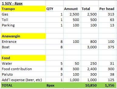
Referring to my #4 tip above, here is a breakdown of our “Forecasted” expenses for this trip. We ended up contributing Php1,450 per head – not bad compared to Php2500++ rate of a packaged tour which typically do not include all meals and miscellaneous expenses yet.

*Boat rental is fixed at Php3000 regardless of # of persons; Actual parking rate given to us is Php150; We did not pay for "Paluto" since we cooked our own food.

*Boat rental is fixed at Php3000 regardless of # of persons; Actual parking rate given to us is Php150; We did not pay for “Paluto” since we cooked our own food.

Contact Information

Here is the contact information of our Boat and guide provider.  I suggest you arrange for your trip at least 1 week before (including all requests – ice, water, or if you’ll be borrowing/renting coolers and tents).

2 Sister’s Boat Rental and Guide – Brgy. Pundaquit, San Antonio, Zambales

Contact Person: Luisa A. Agasa

Contact Numbers: 09196498563 / 09283829947

Overall, I think our weekend getaway was smooth and definitely a blast. Here are more photos from our trip. 🙂

Nagsasa Shoreline

Nagsasa Shoreline. Photo Credits: Simon Floreza

Nagsasa Mountain backdrop

Nagsasa Mountain backdrop. Photo Credits: Simon Floreza

Nagsasa River

Nagsasa River. Photo Credits: Simon Floreza

Nagsasa Camp Site

Nagsasa Camp Site. Photo Credits: Simon FLoreza

Anawangin Deep Well where we wash our food and utensils

Anawangin Deep Well where we wash our food and utensils

Capones lighthouse

Capones lighthouse

Capones Lighthouse view from the top

Capones Lighthouse view from the top